


V600L Laser RTK System
₦4,000,000.00 VAT
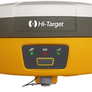
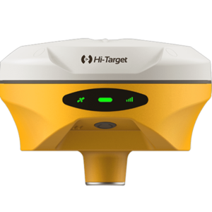
The Hi-Target V600L Laser RTK System is a powerful next-generation GNSS receiver that combines advanced laser measurement, dual-camera imaging, high-performance IMU, and full-constellation tracking for precise, fast, and contactless surveying. Engineered for GNSS-challenged environments, the V600L delivers up to 2 cm laser accuracy, visual stakeout, non-contact measurement, and industry-leading 15–20 km LoRa communication for seamless fieldwork. Lightweight, IP68 rugged, and built for extreme conditions, it’s the ideal RTK system for surveyors working around obstacles, under bridges, near fences, or in semi-enclosed terrains.
Description
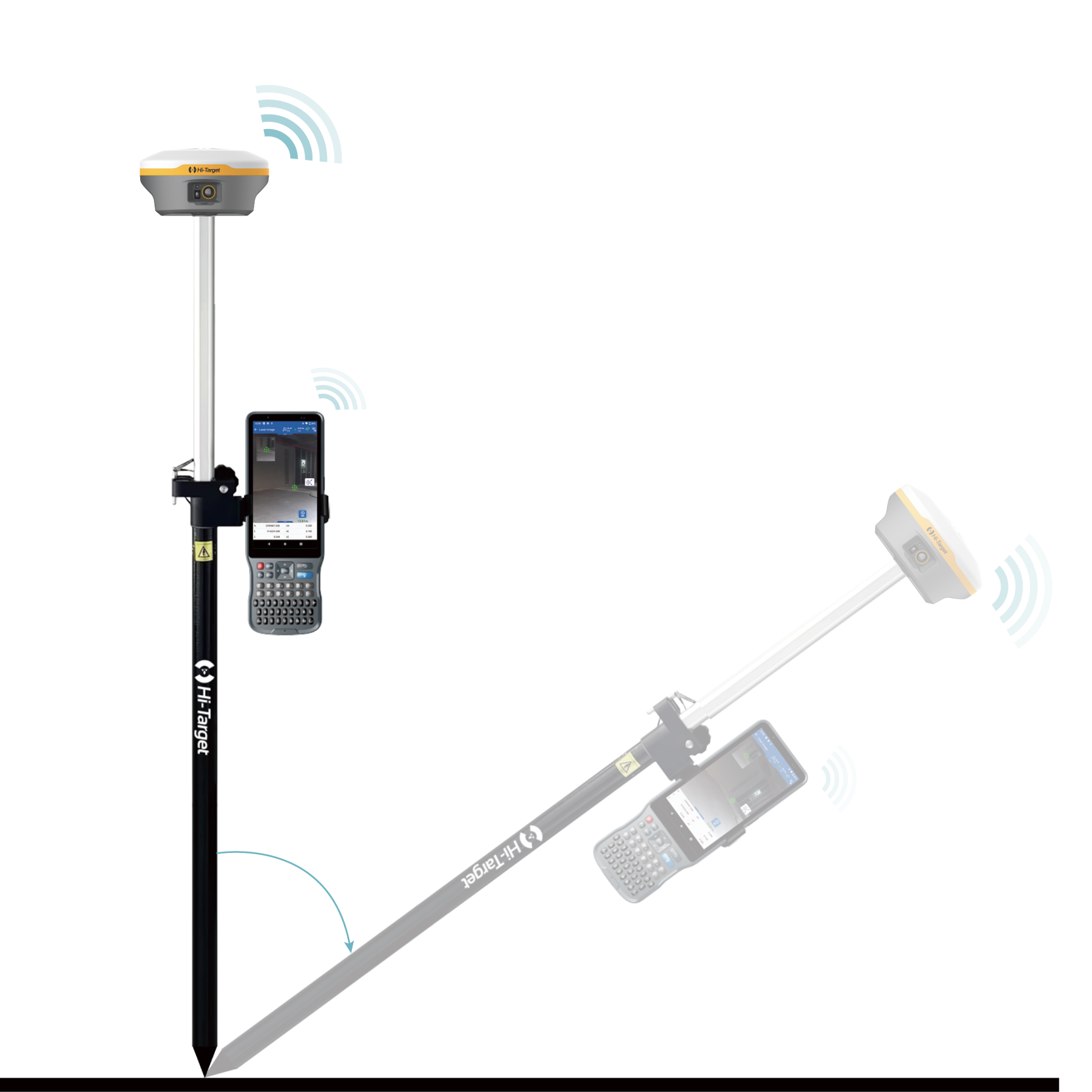
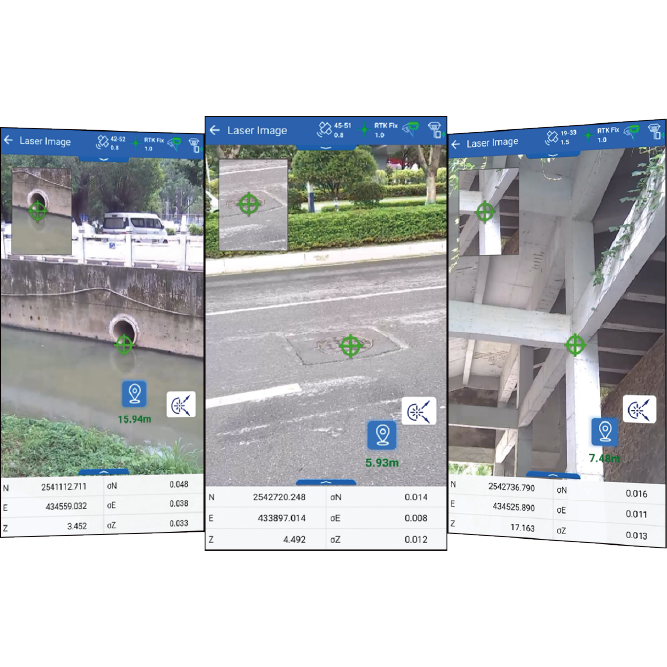
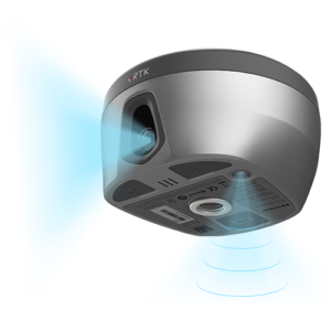
The V600L Laser RTK System from Hi-Target redefines precision surveying with a groundbreaking fusion of GNSS, laser measurement, dual-camera imaging, and advanced IMU technology—delivering reliability and accuracy even where traditional RTK receivers fail. Designed for surveyors who frequently work in obstructed, complex, or GNSS-denied environments, the V600L unlocks new measurement possibilities with visualized laser targeting and non-contact laser accuracy up to 2 cm within 10 meters.
Equipped with a next-generation automotive-grade IMU, the V600L requires no initialization, offering instant measurement readiness and up to 40% better stability on rugged terrain. Its integrated LoRa radio supports cross-brand compatibility and reaches 15–20 km working range, ensuring dependable communication in large outdoor survey areas.
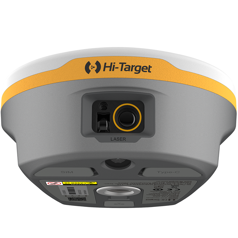
The V600L’s visual laser targeting system displays the laser point directly on-screen, making aiming faster, safer, and more intuitive—perfect for jobs around ditches, fences, walls, traffic lanes, or restricted zones. Combined with real-scene CAD stakeout, users can take advantage of a hybrid environment where CAD models and real-world imagery blend seamlessly for more accurate field layout, improving stakeout efficiency by up to 50%.
Built to withstand extreme environments, the V600L features:
-
IP68 protection for dust, water, and harsh weather
-
MIL-STD-810G shock and vibration resistance
-
Survival of 1.8 m drops onto concrete
-
Ultra-lightweight design at just 0.73 kg
With full-constellation GNSS support—GPS, BDS, GLONASS, Galileo, QZSS, NavIC, SBAS, and PPP—the V600L delivers centimeter-level accuracy in RTK mode and maintains reliable performance through advanced anti-interference and signal reacquisition technology. Its laser-based measurement mode ensures uninterrupted surveying even beneath bridges or in semi-enclosed areas where satellite visibility is poor.
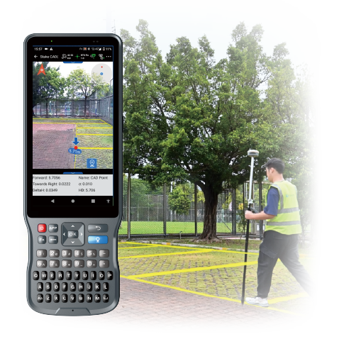
Paired with Hi-Target’s Hi-Survey field software, users gain access to powerful Android-based tools for surveying, road engineering, image-assisted measurement, AR stakeout, and seamless data management across controllers, smartphones, and tablets.
Ideal for:
-
Cadastral & engineering surveys
-
Construction layout & site planning
-
Utility and pipeline measurement
-
Road, bridge & drainage projects
-
Obstructed or GNSS-limited environments
The Hi-Target V600L Laser RTK is a robust, intelligent, and future-ready surveying solution—combining the power of GNSS with the precision of laser technology to give professionals unmatched flexibility, accuracy, and productivity in the field.
Additional information
| Weight | 0.73 kg |
|---|---|
| Dimensions | 130.97 × 68.7 cm |
| GNSS Constellation Support | GPS BDS GLONASS GALILEO QZSS NavIC SBAS PPP |
| GNSS Signals | GPS: L1C/A, L1C, L2P(Y), L2C, L5 BDS: B1I, B2I, B3I, B1C, B2a, B2b GLONASS: L1, L2, L3 GALILEO: E1, E5a, E5b, E6 QZSS: L1, L2, L5, L6* NavIC: L5 SBAS: L1, L2, L5 PPP: B2b-PPP, Galileo E6-HAS Channels: 1408 |
| Positioning Modes | High-Precision Static Static & Fast Static PPP Code Differential GNSS Post-Processing (PPK / Stop & Go) Real-Time Kinematic (RTK) |
| Positioning Accuracy | Static H: 2.5 mm + 0.1 ppm RMS V: 3.5 mm + 0.4 ppm RMS Fast Static H: 2.5 mm + 0.5 ppm RMS V: 5 mm + 0.5 ppm RMS RTK H: 8 mm + 1 ppm RMS V: 15 mm + 1 ppm RMS Code Differential GNSS H: ±0.25 m + 1 ppm RMS V: ±0.5 m + 1 ppm RMS SBAS H: 0.5 m V: 0.85 m Hi-Fix H: RTK + 10 mm/min RMS V: RTK + 20 mm/min RMS Laser Measurement Accuracy: 2 cm within 10 m |
| Initialization | Initialization time (RTK): < 10 s Initialization reliability: > 99.9% Network initialization: 10 min (base), 5 min (rover) Signal reacquisition: < 2 s |
| Time to First Fix (TTFF) | Cold start: < 45 s Hot start: < 30 s |
| Positioning Rate | 1 Hz, 5 Hz, 10 Hz, 20 Hz |
| Tilt Survey Performance | 200 Hz auto-calibration IMU Additional horizontal pole-tilt uncertainty: H: 8 mm + 0.7 mm/° tilt (0–60°) V: 15 mm + 0.7 mm/° tilt (0–60°) |
| Laser Features | Laser product classification: Class 3R Image-assisted measurement AR stakeout support 2 cm accuracy within 10 m |
| Cameras | Front camera Bottom camera Supports AR stakeout Supports image-assisted measurement |
| Communication | Bluetooth: BT 5.2 Power: 1–1.5 W Frequency: 410–470 MHz Protocols: LoRa, Hi-Target, Trimtalk450S, Trimmark III, Satel-3AS, TranSEOT, etc. Working range: 15–20 km Channels: 116 |
| I/O Interface | 1 × USB Type-C 1 × SMA Antenna Port 1 × Nano SIM Slot |
| Physical Specifications | Dimensions: 130.97 mm × 68.7 mm Weight: ≤ 0.73 kg (1.61 lb) LED indicators: Satellite, signal, power Storage: 64 GB ROM Physical button |
| Battery & Power | Internal battery life: RTK Rover (UHF/GSM): up to 20 hrs UHF RTK Base: up to 13 hrs GSM RTK Base: up to 17 hrs Charging: Type-C 5V 2.8A Compatible with smartphone chargers & power banks |
| Environmental | Operating temperature: -40°C to +75°C Storage temperature: -55°C to +85°C Humidity: 100% non-condensing IP68 rating (IEC 60529) Shock & vibration: MIL-STD-810G Free fall resistance: 1.8 m onto concrete |
Only logged in customers who have purchased this product may leave a review.


Reviews
There are no reviews yet.