

IRTK5 GNSS RTK System
₦3,500,000.00 VAT
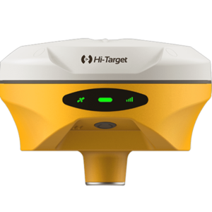
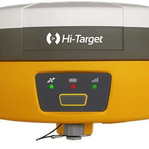
The Hi-Target iRTK5 GNSS RTK System is a next-generation, 1408-channel full-constellation receiver engineered for high-precision surveying, mapping, and construction layout. Featuring a powerful GNSS engine, 360° omni-directional radio antenna, tilt-survey IMU, and Hi-Fix technology, the iRTK5 delivers fast initialization, superior anti-interference performance, and continuous centimeter-level accuracy—even during correction signal outages. Rugged, reliable, and designed for extreme environments, it is a professional-grade RTK solution for surveyors seeking unmatched speed, stability, and field productivity.
Description
The Hi-Target iRTK5 GNSS RTK System sets a new benchmark in high-precision GNSS surveying with a powerful combination of next-generation 1408-channel tracking, full-constellation support, and cutting-edge communication technology. Designed for professional surveyors, engineers, and geospatial practitioners, the iRTK5 delivers exceptional accuracy, stability, and performance in the most demanding field environments.
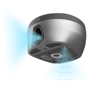
Powered by a full-wave antenna and advanced GNSS engine, the iRTK5 supports GPS, BDS, GLONASS, GALILEO, QZSS, NavIC, SBAS, and PPP signals for robust tracking and enhanced anti-noise performance. Its Hi-Fix technology maintains RTK-level precision even during temporary correction link outages, ensuring uninterrupted productivity on large-scale projects.
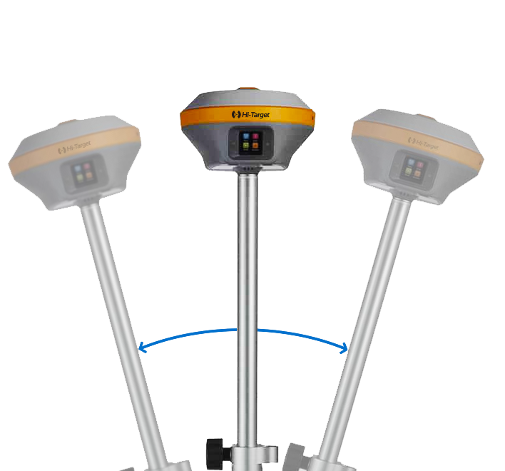
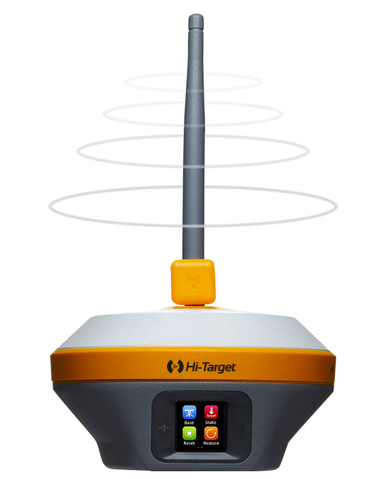
The system features a 360° omni-directional UHF antenna with multi-protocol compatibility—Hi-Target, TRIMTALK450S, TRIMMARK III, TRANSEOT, SATEL-3AS and more—allowing seamless communication across equipment brands. The extended radio range boosts RTK communication distances by up to 20%, enabling reliable performance over 8–15 km in optimal conditions.
With a built-in IMU tilt survey module, the iRTK5 eliminates the need for calibration or leveling. Users can begin measuring immediately, achieving an accuracy of within 2 cm up to 30° tilt, and up to 20% faster workflows compared to traditional bubble leveling. The IMU is highly resistant to magnetic interference, ensuring stable results even near metal structures and high-interference zones.
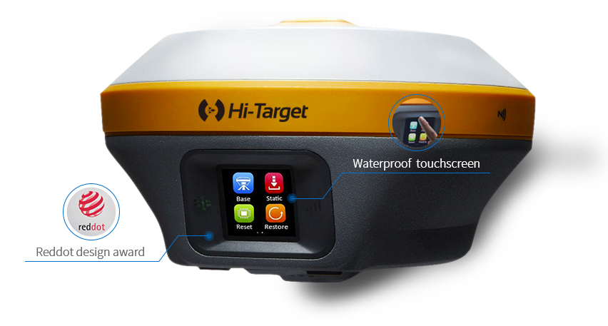
The iRTK5 also shines in versatility and durability. Its IP67-rated housing, MIL-STD-810G shock protection, and ability to withstand 2-meter drops onto concrete make it exceptionally reliable in rugged conditions. An intelligent temperature-control system optimizes performance from -40°C to +75°C, ensuring consistent accuracy across diverse terrains and climates.
new-iRTK5-GNSS-RTK-Brochure-140…
For seamless field-to-office workflows, the system supports:
-
Dual-format static data recording (GNS + RINEX)
-
Real-time NMEA-0183 output
-
Network RTK models (VRS, FKP, MAC)
-
1–20 Hz output rates
-
CMR and RTCM protocols
The iHand55 Android controller enhances usability with a bright 5.5″ outdoor screen, dual SIM capability, fast processor, and Hi-Survey software—offering intuitive UI, online basemaps, DXF/SHP support, and professional road engineering modules.
new-iRTK5-GNSS-RTK-Brochure-140…
Ideal for:
-
Cadastral and engineering surveys
-
Road and infrastructure layout
-
Construction staking
-
Utility mapping & pipeline alignment
-
Topographical mapping
-
Large-area GNSS RTK projects
The Hi-Target iRTK5 is a rugged, scalable, and future-ready GNSS RTK receiver engineered for professionals who demand accuracy, stability, long-range communication, and high performance in every environment. Whether for construction, engineering, geospatial mapping, or cadastral work, the iRTK5 delivers an industry-leading RTK solution that boosts productivity and ensures reliable results on every project.
Additional information
| GNSS Constellations & Channels | Channels: 1408 GPS: L1C/A, L1C, L2P(Y), L2C, L5 BDS: B1I, B2I, B3I, B1C, B2a, B2b GLONASS: L1, L2, L3 GALILEO: E1, E5a, E5b, E6 QZSS: L1, L2, L5, L6* NavIC: L5 SBAS: L1, L2, L5 PPP: B2b-PPP, Galileo E6-HAS |
|---|---|
| Hardware Specifications | Physical Dimensions: 158 mm × 98 mm Weight: < 1.3 kg (with battery) Display: 1.3" OLED Touch Buttons: 1 LED indicators: Satellite, Signal, Power |
| Positioning Performance | High-Precision Static Horizontal: 2.5 mm + 0.1 ppm RMS Vertical: 3.5 mm + 0.4 ppm RMS Fast Static / PPK (Stop & Go) Horizontal: 2.5 mm + 0.5 ppm RMS Vertical: 5 mm + 0.5 ppm RMS Code Differential GNSS Horizontal: 3 mm + 1 ppm RMS Vertical: 5 mm + 1 ppm RMS DGPS Horizontal: ±0.25 m + 1 ppm RMS Vertical: ±0.5 m + 1 ppm RMS SBAS 0.5 m (H), 0.85 m (V) PPP Horizontal: 10 cm Vertical: 20 cm Single Baseline RTK Horizontal: 8 mm + 1 ppm RMS Vertical: 15 mm + 1 ppm RMS Network RTK (VRS / FKP / MAC) Horizontal: 8 mm + 1 ppm RMS Vertical: 15 mm + 1 ppm RMS Hi-Fix Horizontal: RTK + 10 mm/min RMS Vertical: RTK + 20 mm/min RMS |
| Tilt Survey Performance | Horizontal: 8 mm + 0.5 ppm RMS Vertical: 15 mm + 0.5 ppm RMS |
| System Configuration | Data Storage: 16 GB internal (circular) Static data formats: GNS + RINEX (dual format) Output formats: NMEA-0183 Output rate: 1–20 Hz Network models: VRS, FKP, MAC Supported protocols: RTCM2.x, RTCM3.x, CMR NFC: Supported |
| Initialization | RTK initialization time: 2–10 seconds Initialization reliability: > 99.99% Network RTK base init: 10 min Rover init: 5 min |
| Communication | Network Communication Supports 4G / LTE / WCDMA / EDGE / GPRS / GSM Wi-Fi: 2.4 GHz, 802.11 b/g/n Network RTK working range: 20–50 km Internal UHF Radio Frequency: 403–473 MHz Power: 1–5 W Range: 3–5 km (optimal 8–15 km) Protocols: HI-TARGET, TRIMTALK450S, TRIMMARK III, SATEL-3AS, TRANSEOT External UHF Radio Frequency: 403–473 MHz Power: 10 W / 35 W Range: 8–10 km (optimal 15–20 km) Third-party compatible |
| Environmental | Operating temperature: -40°C to +75°C Storage temperature: -50°C to +85°C Humidity: 100% condensing Waterproof/Dustproof: IP67 (1 m immersion) Shock/Vibration: MIL-STD-810G 514.6 Free-fall: 2 m onto concrete (MIL-STD-810G 516.6) Anti-salt spray: MIL-STD-810G 509.4 (96h) |
| Electrical & Power | External power: 6–28V DC (5-pin), over-discharge protection Switches automatically between internal & external power Battery: 7.2V, 6900 mAh, removable Battery life: RTK Rover (UHF/Cellular): 24 hours Quick charge: 3.5 hours Power consumption: 4.4W |
| I/O Interface | Bluetooth 4.2 / 2.1 + EDR USB 3.0 + OTG SMA Antenna port SIM card slot DC power port (5-pin) |
Only logged in customers who have purchased this product may leave a review.


Reviews
There are no reviews yet.