

HD-MAX II Dual-Frequency Echo Sounder
₦15,000,000.00 VAT
The HD-MAX II Dual-Frequency Echo Sounder delivers unmatched accuracy and efficiency for hydrographic surveys, dredging, high-turbidity mapping, and deep-water bathymetry. Featuring 24kHz/200kHz transducers, real-time sound velocity calibration, a rugged IP66 magnesium-alloy housing, and a powerful 15″ Windows-based control unit, it ensures precise, stable, and reliable underwater measurements in any environment.
Description
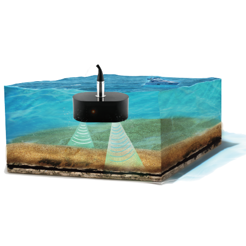
The HD-MAX II Dual-Frequency Echo Sounder is a high-performance hydrographic surveying system designed for professionals who demand accuracy, durability, and seamless workflow integration. Built with a robust magnesium-alloy housing and engineered to operate in the harshest marine environments, it provides reliable and precise underwater depth measurements across a wide range of applications—including dredging, siltation measurement, deep-water bathymetry, high turbidity environments, and submarine terrain mapping.
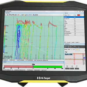
Powered by advanced dual-frequency technology (24kHz & 200kHz), the HD-MAX II delivers exceptional detail and penetration, allowing operators to capture accurate shallow and deep-water profiles simultaneously. Its integrated temperature sensor automatically calibrates sound velocity in real-time, ensuring consistent and reliable results even in dynamic water conditions. With a rapid 50Hz ping rate and adaptive depth algorithm, the system provides fast, stable data acquisition across complex underwater landscapes.
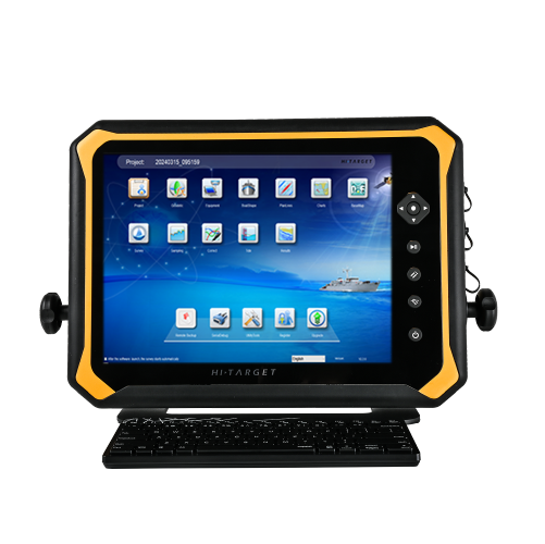
Designed for maximum usability, the HD-MAX II features a bright 15-inch high-resolution display, intuitive physical controls, and an optimized software interface that simplifies data collection, survey planning, deployment, and post-processing. The integrated Windows 10-based host computer includes 16GB RAM, a fast 2.0GHz quad-core processor, and 128GB + 1TB SSD storage, enabling efficient onboard processing of high-volume survey datasets.
Field teams benefit from its robust connectivity options, including PPS, Trigger, RS232, RJ45, HDMI, USB, and multi-format data output compatible with leading hydrographic standards such as NMEA 0183, DESO 25, Echotrac, ODOM, Bathy, and Knudsen. The IP66-rated enclosure ensures long-term durability against dust, water spray, and challenging weather conditions.
With broad compatibility, wide depth range (0.15–300m @ 200kHz and up to 2000m @ 24kHz), industry-leading accuracy of ±0.01m, and advanced hydrographic processing tools, the HD-MAX II sets a new standard for professional underwater surveying. Whether you’re managing dredging projects, mapping seafloors, monitoring sedimentation, or conducting inland water studies, this powerful echo sounder delivers reliable, high-precision results every time.
Additional information
| General | Model: HD-MAX II Product Type: Dual-Frequency Echo Sounder Applications: Bathymetry, dredging, sediment removal, high turbidity measurements, deep-water surveys, submarine topography |
|---|---|
| Echo Sounder Unit | Dimensions: 441 × 105 × 324 mm Weight: 8.1 kg Housing Material: Magnesium alloy IP Rating: IP66 Ping Rate: 50 Hz Power Consumption: 50W Input Power: 10–30 VDC, 110–240 VAC Operating Temperature: -5°C to +55°C Storage Temperature: -20°C to +60°C |
| Display / Control Unit | Screen Size: 15 inches Resolution: 1280 × 1024 @ 60Hz CPU: 2.0 GHz quad-core RAM: 16 GB Internal Storage: 128 GB SSD + 1 TB SSD Operating System: Windows 10 |
| Connectivity & Interfaces | Interfaces: PPS ×1 Trigger ×1 RJ45 ×1 RS232 ×3 USB ×3 HDMI ×1 Transducer ×1 Power ×1 Supported Data Formats: NMEA 0183 Echotrac ODOM Knudsen Bathy DESO 25 |
| Transducer (High Frequency Channel – 200kHz) | Frequency: 200kHz Depth Range: 0.15–300 m Accuracy: ±0.01 m ±0.1% of depth Resolution: 1 cm Beam Angle: 6.9° ± 2° Temperature Sensor: -55°C to +125°C, 0.5°C resolution |
| Transducer (Low Frequency Channel – 24kHz) | Frequency Range: 10–50 kHz Operating Frequency: 24kHz Depth Range: 1–2000 m Accuracy: ±0.1 m ±0.1% of depth Resolution: 10 cm Beam Angle: 34.1° ± 3° |
| Software | Included Software Functions: Project management Navigation & basemap Coordinate system support Multi-sensor integration Real-time data acquisition Planned deployment Data processing Multi-sensor calibration Data export (multiple formats) |
Only logged in customers who have purchased this product may leave a review.


Reviews
There are no reviews yet.