


V700S SLAM RTK System
₦8,500,000.00 VAT
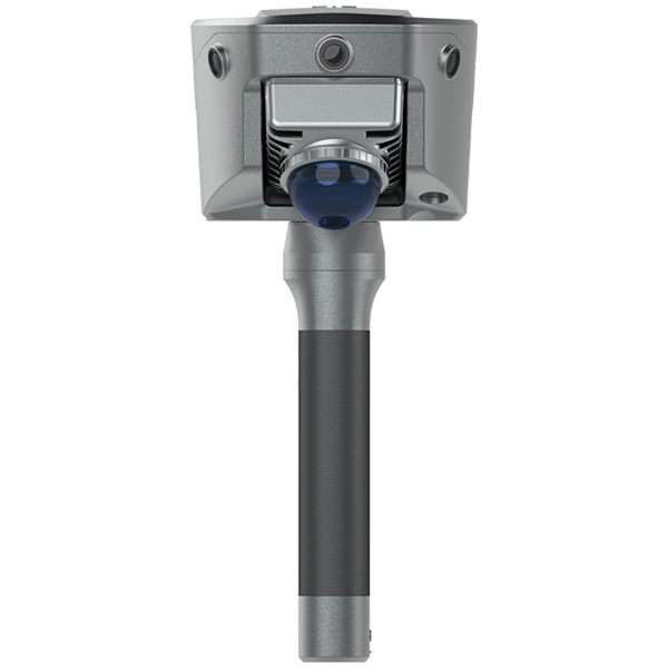
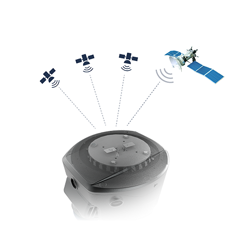
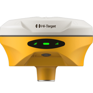
The Hi-Target V700S SLAM RTK System is a next-generation, multi-sensor GNSS receiver built for high-precision 3D mapping, laser scanning, and real-time positioning in challenging environments. With 1408-channel full-constellation tracking, laser reverse positioning, and RTK + SLAM fusion, it delivers uninterrupted centimeter-level accuracy even under bridges, tunnels, and GNSS-denied areas. Compact, rugged, and equipped with advanced Android processing, the V700S enables fast scanning, contactless measurement, and seamless field-to-office workflows for surveyors, engineers, and geospatial professionals.
Description
The V700S SLAM RTK System is Hi-Target’s most advanced all-in-one GNSS and laser-mapping solution, engineered for surveyors and geospatial professionals who need high-accuracy 3D data capture in both outdoor and GNSS-restricted environments. Combining full-constellation GNSS, SLAM technology, and laser point cloud processing, the V700S delivers unmatched efficiency, precision, and adaptability across demanding field conditions.
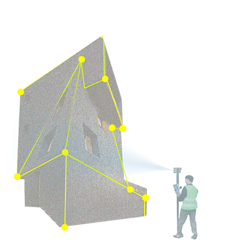
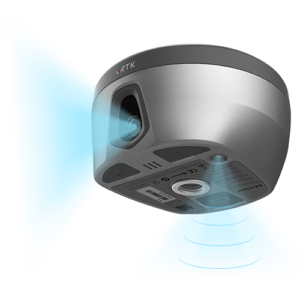
Powered by a 1408-channel GNSS engine, the V700S ensures strong signal reception, anti-interference performance, and centimeter-level accuracy even in dense urban areas. Its Laser Reverse Positioning Technology automatically switches to laser-based positioning when GNSS signals weaken—letting you continue measuring under bridges, culverts, eaves, or fully enclosed structures. This seamless transition guarantees continuous data collection without returning to control points or resurveying difficult areas.
With RTK + SLAM fusion, the system produces real-time aligned point clouds and unified coordinates (BLH/NEH), eliminating the need for external control points and drastically reducing field time. The contactless measurement feature allows users to simply capture a photo and instantly generate accurate coordinates—with up to 5 cm precision, doubling field productivity.
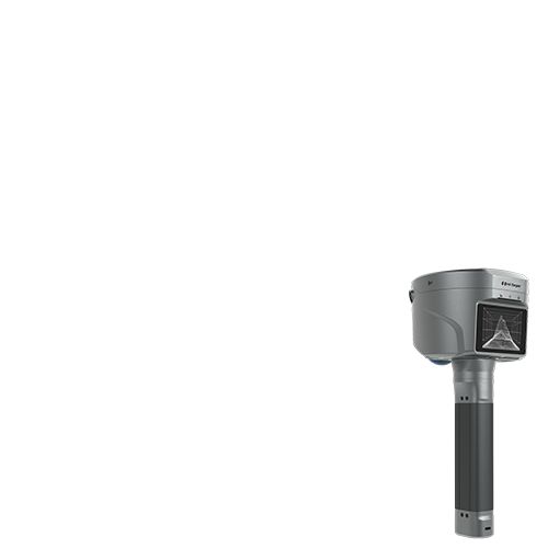
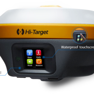
The V700S includes a rugged 8-inch Android 10 tablet, equipped with a 2.0GHz 8-core processor, 6+128GB memory, and long-lasting battery for uninterrupted fieldwork. The Hi-Survey software suite delivers real-time point cloud processing, accuracy heatmaps, CAD integration, and advanced visualization tools, while the Hi-LiDAR desktop software provides sub-2 cm point cloud refinement, excavation calculations, section drafting, and full post-processing capabilities.
Compact, lightweight, and built with a secure screw-lock mechanism, the V700S is designed for professionals working in:
-
Urban renewal & construction
-
Tunnel & underground infrastructure surveys
-
Forestry & environmental mapping
-
Pipeline & utility monitoring
-
Architectural & renovation measurements
For surveyors needing a powerful, field-ready system that merges high-precision GNSS, laser scanning, and SLAM into one platform, the V700S SLAM RTK is one of the most capable and versatile solutions on the market—delivering accuracy, speed, and reliability wherever your projects take you.
Additional information
| Weight | 1.68 kg |
|---|---|
| GNSS Signal | GPS: L1C/A, L1C, L2P(Y), L2C, L5 BDS: B1I, B2I, B3I, B1C, B2a, B2b GLONASS: L1, L2, L3 GALILEO: E1, E5a, E5b, E6 QZSS: L1, L2, L5, L6 NavIC: L5 SBAS: L1, L2, L5 PPP: B2b-PPP, E6-HAS |
| Configuration | ASCII: NMEA-0183, Binary Output Rate: 1Hz~20Hz Static Data Format: GNS, Rinex Real Time Kinematic: RTCM2.X, RTCM3.X Network Mode: VRS, FKP, MAC, Support NTRIP protocol Operation System: Linux Storage: Circulating 512GB ROM |
| Function & Sensors | Camera: 3 professional HD front cameras, 1 bottom camera AR Stakeout & Image Measurement: Working distance 2~15 m, single photo can acquire multiple points with 5 cm accuracy Laser Scanner: Point Measurement Rate 200,000 pts/sec, Class 1 eye safe, Range: 0.1~40 m @10%, 0.1~70 m @80%, FOV H: 360°, V: 59° IMU: Built-in high-precision module, Update Rate 200 Hz |
| I/O Interface & Network | USB Type C port, SMA antenna port, Nano SIM card slot Wi-Fi: IEEE 802.11a/b/g/n/ac/ax, 2.4GHz/5GHz, hotspot support Bluetooth: 5.2 Internal UHF Radio: Power 0.5W/1W adjustable, Frequency 410–470 MHz, Protocols: HI-TARGET, TRIMTALK450S, TRIMMARK III, SATEL-3AS, TRANSEOT, Channel 116 (16 scalable) |
| Control & Display | Physical Button: Single button Display: 2.8 inch, 480×640 pixel touch screen Advanced Functions: Mode, accuracy, network selection, NFC, WebUI, firmware upgrade via u-disk Intelligence Application: Intelligent voice, self-check, message push, online upgrade, remote control |
| Power & Battery | Built-in battery: RTK rover 4 h, SLAM 2 h External battery: RTK rover 10 h, SLAM 5 h USB 45W fast charging, fully charged in 2 h |
| Physical & Environmental | Size: Φ134.4 mm × 109.9 mm Weight: 1.68 kg IP Rating: IP64 Humidity: 100% non-condensing Operating Temperature: -40℃~+70℃ Storage Temperature: -40℃~+70℃ |
Only logged in customers who have purchased this product may leave a review.


Reviews
There are no reviews yet.