Showing 1–9 of 22 results
-
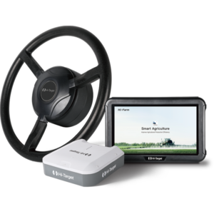
The FARMSTAR F3 Auto-Steering System is a high-precision GNSS-guided agricultural steering solution that delivers ±2.5 cm pass-to-pass accuracy, automated U-turns, multi-line guidance, slope compensation, and full ISOBUS compatibility. With fast setup, cloud-based farm management, and support for speeds from 0.1 to 30 km/h, it boosts farm efficiency, reduces input waste, and maximizes yield performance across all field operations.
-
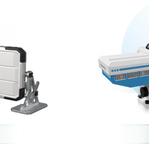
The Hi-Target Ground-Based InSAR Monitoring System delivers ultra-precise, real-time deformation and displacement monitoring across distances up to 5 km. Built on advanced SAR and Interferometric Radar technology, it provides sub-millimeter accuracy for long-term and emergency monitoring of mountains, mines, dams, and other critical structures. With a rugged, all-weather design and automated 3D visualization, alerts, and reporting, this system ensures reliable, continuous safety monitoring in the harshest environments.
-

₦10,000,000.00 VAT
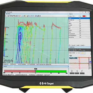
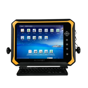
The HD-Lite Compact Single Beam Echo Sounder is a rugged, portable, and highly accurate hydrographic survey solution built with a 15″ PC-integrated display, 200kHz sonar technology, and a powerful dual-core onboard computer. Designed for demanding bathymetric applications, it delivers precise depth measurements up to 200 meters with ±0.01m accuracy, making it ideal for marine surveying, dredging, inland water mapping, and environmental monitoring.
-
₦15,000,000.00 VAT
The HD-MAX II Dual-Frequency Echo Sounder delivers unmatched accuracy and efficiency for hydrographic surveys, dredging, high-turbidity mapping, and deep-water bathymetry. Featuring 24kHz/200kHz transducers, real-time sound velocity calibration, a rugged IP66 magnesium-alloy housing, and a powerful 15″ Windows-based control unit, it ensures precise, stable, and reliable underwater measurements in any environment.
-

₦1,000,000.00 VAT
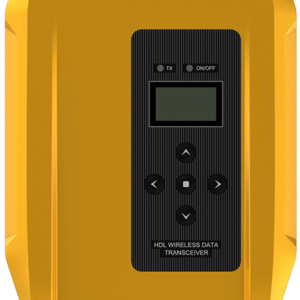
The Hi-Target HDL460A Multi-Protocol Radio is a high-performance external UHF modem engineered for long-range, stable, and reliable GNSS/RTK data communication. With up to 35W output, adaptive frequency matching, wide protocol compatibility, IP67 durability, and a transmission range of up to 20 km, the HDL460A provides professional-grade connectivity for demanding surveying and geospatial applications.
-

₦500,000.00 VAT
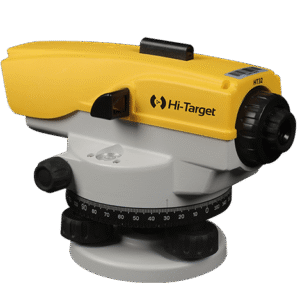
The HT-32 Auto Level offers rugged durability, high precision, and 32x magnification for reliable leveling in construction, surveying, engineering, and site layout tasks. Featuring an X-style air damping compensator, IP66 protection, and a 1mm accuracy over 1km double levelling, it delivers stable performance even under vibration and harsh weather conditions.
-

₦3,500,000.00 VAT
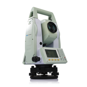
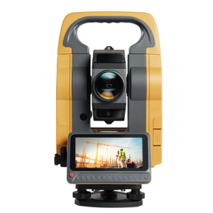
The HTS-420R Total Station delivers powerful long-range performance with precision 2″ angle measurement, 600m reflectorless EDM, and up to 7500m prism range. Built for construction, engineering, mining, roadworks, and control surveys, it features absolute encoding technology, dual-axis compensation, fast data transfer, long battery life, and IP65 protection for reliable field performance in all conditions.
-
₦4,000,000.00 VAT
The HTS-521L10 Long-Range Total Station delivers outstanding precision, speed, and stability with its advanced EDM technology, 1000m reflectorless range, up to 6000m prism range, HD color display, dual-axis tilt sensor, and high-capacity battery. Designed for construction, mining, roadworks, tunnels, and control surveys, it offers fast measurement, strong connectivity, and dependable performance in tough environments.
-
₦5,000,000.00 VAT
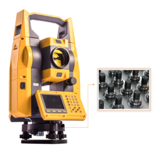
The HTS-720 Android Total Station delivers advanced precision, fast data processing, and intelligent field automation. Featuring a 5.5-inch HD touchscreen, built-in 8MP camera, visual stakeout, CAD stakeout, and ultra-long EDM range up to 6000m, it streamlines surveying tasks for roads, bridges, tunnels, mining, railways, and construction projects. Powered by Android and Hi-Target’s intuitive T-Survey software, the HTS-720 offers unmatched ease, speed, and measurement accuracy.